Download Google Earth the 5.0 version by going to the link below:
http://www.google.com/earth/index.html

After Google Earth is downloaded and opened, a pop-up with start-up tips will be accessible to learn what the icons and features of Google Earth are.
- When you search for places or businesses use the search panel to help you locate your desired destination.
- The search feature can be used if you have any of the following information: name, address, coordinates, and keywords.
The link to the User's Guide is
http://earth.google.com/support/bin/static.py?page=guide_toc.cs
In the User's Guide, you will find....
The following topics to learn Google Earth basics - navigating the globe, searching, printing, and more:
Getting to Know Google Earth
The following diagram describes some of the features available in the main window of Google Earth:
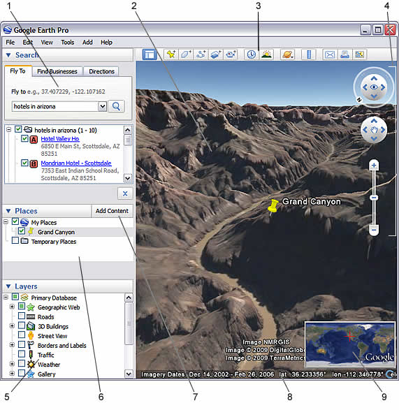
- Search panel - Use this to find places and directions and manage search results. Google Earth EC may display additional tabs here.
- 3D Viewer - View the globe and its terrain in this window.
- Toolbar buttons - See below.
- Navigation controls - Use these to zoom, look and move around (see below).
- Layers panel - Use this to display points of interest.
- Places panel - Use this to locate, save, organize and revisit placemarks.
- Add Content - Click this to import exciting content from the KML Gallery
- Status bar - View coordinate, elevation, imagery date and streaming status here.
- Overview map - Use this for an additional perspective of the Earth.
Click the following toolbar buttons to...
Five Cool, Easy Things You Can Do in Google Earth
Want to jump in and start having fun with Google Earth? Try any of the the following:
- View an image of your home, school or any place on Earth - Click Fly To. Enter the location in the input box and click the Search button. In the search results (Places panel), double click the location. Google Earth flies you to this location.
 Search button
- Tour the world - In the Places panel, open the Learn and Explore folder and double click Explore.
- Get driving directions from one place to another and fly (follow) the route - See Getting Directions and Touring the Route.
- View other cool locations and features created by other Google Earth users - In the Layers panel, check Community Showcase. Interesting placemarks and other features appear in the 3D viewer. Double click these points of interest to view and explore. See Using Points of Interest (POIs) for more information.
- View 3D terrain of a place - This is more fun with hilly or mountainous terrain, such as the Grand Canyon. Go to a location (see number 1). When the view shows the location, use the zoom slider to tilt the terrain. See Using the Navigational Controls and Tilting and Viewing Hilly Terrain for more information.
Some websites that have Google Earth Lesson Plans include:
http://gelessons.com/lessons/
http://www.shambles.net/pages/learning/GeogP/gearthplan/
http://sitescontent.google.com/google-earth-for-educators/Home/google-earth-lesson-plans
http://www.atsolutions.info/google_earth/index.asp
http://sitescontent.google.com/google-earth-for-educators/Home/tutorials-and-tips
Comments (0)
You don't have permission to comment on this page.